GoPal 6.x Kartenfarben: Unterschied zwischen den Versionen
Keine Bearbeitungszusammenfassung |
|||
| Zeile 206: | Zeile 206: | ||
|- valign="middle" | |- valign="middle" | ||
| '' woodland '' | | '' woodland '' | ||
| '' | | '' Wald '' | ||
|- valign="middle" | |- valign="middle" | ||
Version vom 17. Juli 2011, 22:00 Uhr
Vorlage:PDF
Allgemeines
Ab der GoPal 6-92972 Version gibt es nun auch Einstellungsdateien um die Kartenfarben zu beeinflussen.
Beispiel Erklärung
Beispiel Eintrag aus einer mxf Datei
   <drawingconfiguration name="motorway">
     <pen>
       <color dccolor="0xFF525252" />
       <style type="antialiasing" />
     </pen>
     <brush>
       <color dccolor="0xFF00F1FF" />
       <style type="antialiasing" />
     </brush>
   </drawingconfiguration>
Bezeichner (original Name)
<drawingconfiguration name="motorway">
Farbwert des Randes
<color dccolor="0xFF525252" />
Farbwert des Feldes
<color dccolor="0xFF00F1FF" />
Farbänderungen in den Karten
Die Definitionen (Vorgaben) zu den Farbinformationen in den Karten sind in mehreren Dateien in \My Flash Disk\Navigation\MapConfigs\mapconfig_*.* hinterlegt. Es wird dabei zwischen Tag- und Nachtdesign unterschieden (mapconfig_1_0.mbf / mapconfig_1_1.mbf).
Analog zur Logik PFSkin.skn/*.bsf können hier in den Dateien mit dem Suffix *.mxf Änderungen mit einem normalen ASCII-Editor vorgenommen werden, die aber dann erst wirksam werden, wenn nach dem Übertragen auf den PNA auch die korrespondierende *.mbf-Datei gelöscht wird.
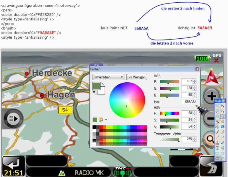
Bei Änderungen mit Paint.NET bspw. ist aber zu beachten, dass der Farbcode (Angabe in 'RGB') konvertiert/umgewandelt werden muss in 'BGR', wie folgendes Beispiel zeigt:

Liste der Farbelemente und Ihre Bedeutung
| original Name | Bedeutung |
|---|---|
| motorway | Autobahn |
| dualcarriageway | Bundesstraße |
| expressway | Landstraße |
| countryroad | Hauptstraße |
| urbanroad | normale Straße |
| pedestrianzone | Fussgängerzone |
| footway | Fussweg |
| ferry | Fährverbindungen |
| railway | Schienen |
| international_boundary | Landesgrenzen |
| national_boundary | Bundeslandgrenzen |
| waterway | Wasserwege |
| motorway_toll | Mautgebühr |
| major_contour_line | Haupt-Höhenlinie/Hauptkamm |
| minor_contour_line | untergeordnete Höhenlinie |
| subway | U-Bahn |
| tramway | Strassenbahn |
| cartrain | Autoreisezug |
| aircraft | Flugzeug |
| airport | Flughafen |
| beach | Strand |
| building | Gebäude |
| built_up | Bebauung / Ortsteil |
| canal | Kanal |
| cemetery | Friedhof |
| golfcourse | Golfplatz |
| harbour_port | Hafen |
| hospital | Krankenhaus / Hospital / Klinik |
| industrial_harbour | Industriehafen |
| industry | Industriegebiete |
| island | Insel |
| lake | See |
| moor | Moor |
| ocean | Ocean |
| park | Park |
| river | Fluss |
| school | Schule |
| shoppingcenter | Einkaufscenter |
| stadium | Stadion |
| university_college | Universität / College |
| woodland | Wald |
| company | |
| topographic_contour_50 | |
| topographic_contour_100 | |
| topographic_contour_200 | |
| topographic_contour_500 | |
| topographic_contour_1000 | |
| topographic_contour_1500 | |
| topographic_contour_2000 | |
| topographic_contour_3000 | |
| topographic_contour_4000 | |
| city_label | Städtenamen |
| capital_city_label | Hauptstädtenamen |
| road_label | Strassennamen |
| route_active_subtour_1 | |
| route_active_subtour_2 | |
| route_active_subtour_3 | |
| route_active_subtour_4 | |
| route_active_subtour_5 | |
| route_active_subtour_6 | |
| route_active_subtour_7 | |
| route_active_subtour_8 | |
| route_active_subtour_9 | |
| route_active_subtour_10 | |
| route_active_subtour_11 | |
| route_active_subtour_12 | |
| route_active_subtour_13 | |
| route_active_subtour_14 | |
| route_active_subtour_15 | |
| route_tour_1 | |
| route_tour_2 | |
| route_tour_3 | |
| route_tour_4 | |
| route_tour_5 | |
| route_tour_6 | |
| route_tour_7 | |
| route_tour_8 | |
| route_tour_9 | |
| route_tour_10 | |
| route_tour_11 | |
| route_tour_12 | |
| route_tour_13 | |
| route_tour_14 | |
| route_tour_15 | |
| route_restricted_active | |
| route_restricted_tour_1 | |
| route_restricted_tour_2 | |
| route_restricted_tour_3 | |
| route_restricted_tour_4 | |
| route_restricted_tour_5 | |
| route_restricted_tour_6 | |
| route_restricted_tour_7 | |
| route_restricted_tour_8 | |
| route_restricted_tour_9 | |
| route_restricted_tour_10 | |
| route_restricted_tour_11 | |
| route_restricted_tour_12 | |
| route_restricted_tour_13 | |
| route_restricted_tour_14 | |
| route_restricted_tour_15 | |
| route_off_road_active | |
| route_off_road_tour_1 | |
| route_off_road_tour_2 | |
| route_off_road_tour_3 | |
| route_off_road_tour_4 | |
| route_off_road_tour_5 | |
| route_off_road_tour_6 | |
| route_off_road_tour_7 | |
| route_off_road_tour_8 | |
| route_off_road_tour_9 | |
| route_off_road_tour_10 | |
| route_off_road_tour_11 | |
| route_off_road_tour_12 | |
| route_off_road_tour_13 | |
| route_off_road_tour_14 | |
| route_off_road_tour_15 | |
| route_selected_active | Aktive Route in der Karte |
| route_selected_tour_1 | Alternativ Routenfarbe 1 |
| route_selected_tour_2 | Alternativ Routenfarbe 2 |
| route_selected_tour_3 | Alternativ Routenfarbe 3 |
| route_selected_tour_4 | |
| route_selected_tour_5 | |
| route_selected_tour_6 | |
| route_selected_tour_7 | |
| route_selected_tour_8 | |
| route_selected_tour_9 | |
| route_selected_tour_10 | |
| route_selected_tour_11 | |
| route_selected_tour_12 | |
| route_selected_tour_13 | |
| route_selected_tour_14 | |
| route_selected_tour_15 | |
| route_blocking | |
| edge_highlighting | |
| tunnel | |
| bread_crumb_trail | |
| manoeuvre_arrowfirst | Pfeil next Manöver |
| manoeuvre_arrownormal | Pfeil next next Manöver |
| one_way_arrows | Einbahnstrassenpfeil |
| direction_arrow | Richtungspfeil |
| hiking_trail_main | |
| hiking_trail_other | |
| map_background | Gebiet außerhalb |
| sky_background | |
| fog | |
| motorway_exit_marker | |
| manoeuvre_marker | |
| lane_guidance_marker | |
| restricted_road | |
| tti_message_arrow_onroute | |
| tti_message_arrow_offroute | |
| tti_message_arrow_wason | |
| polygon_label | |
| poi_label | |
| enclosed_traffic_area_road |
Die eigentliche mxf Datei hat noch weitere Einträge, diese sind dann aber nur noch für TMC Symbole zuständig und ein paar Steuerungsbefehle. Ich würde vorerst nicht empfehlen an diesen Werten etwas zu ändern.